The Nordic region, once burdened under the weight of massive glaciers during the last Ice Age, is gradually rising above sea level as the ice sheets have long since disappeared. This slow but ongoing land movement is known as the post-glacial rebound effect, a process where the Earth’s crust slowly adjusts after being compressed by the weight of the glaciers. Over time, this movement not only alters the landscape but also affects the Earth’s gravitational pull. Two scientists from Sweden’s KTH Royal Institute of Technology, Mohammad Bagherbandi and Lars Sjöberg, have refined methods for measuring and predicting these small, yet important, gravitational changes, providing new insights into the region’s geophysical behavior.
For over three decades, Bagherbandi and Sjöberg have studied this phenomenon in the Ferroscandinavian peninsula, a region that includes parts of Sweden, Norway, Finland, and Russia. Their latest research, published in the Journal of Geodesy, takes a fresh approach to monitoring the ongoing land movement and its impact on the Earth’s gravitational field. The study builds on earlier efforts, but this time, the scientists used an innovative combination of remote satellite sensing, terrestrial gravity data, and 3D GPS positioning systems.
A Refined Measurement Method
The researchers have developed a more precise technique for tracking the rise of land in the Nordic region. This method combines several advanced technologies:
- Satellite Remote Sensing: Satellites provide accurate data on land movement over time, offering a bird’s-eye view of the gradual changes in the Earth’s surface.
- Terrestrial Gravity Measurements: Instruments on the ground measure small variations in gravity across the region. These variations are influenced by changes in the density of the Earth’s crust and mantle as the land slowly rises.
- 3D GPS Positioning: The use of GPS and similar satellite positioning systems offers detailed, high-precision measurements of the land’s vertical displacement.
By combining these data sources, the researchers were able to enhance the accuracy of their models and uncover some surprising new findings.
Discovering New Details About Earth’s Crust
One of the key discoveries from this research is that the density of the upper mantle beneath the Nordic region is higher than previously believed. Specifically, the density is approximately 3,546 kilograms per cubic meter, a slight increase compared to earlier estimates. This finding has significant implications for understanding both the post-glacial rebound and the gravitational changes in the region.
The density of the Earth’s mantle plays a crucial role in determining how much gravity is affected by land movement. The rebound of the land, which is estimated to rise by about 1 cm per year, is influenced by both the land’s density and its movement. When the glaciers melted, the land was relieved from the immense pressure they exerted, and it began to gradually “bounce back” or lift. This rebound not only raises the land but also impacts the local gravitational field, which scientists can measure to better understand these slow, ongoing processes.
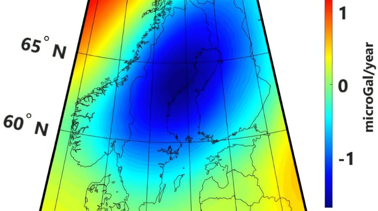
Weakest Gravity in Västerbotten
The study also identified Västerbotten, a northern county in Sweden, as the area with the weakest gravity in the Nordic region. This finding is important because gravity varies across the Earth due to the shape and density of the crust. The lowest gravity is located just below the Arctic Circle, where the crust is still adjusting to the loss of ice from the Ice Age. As the land continues to rise in this area, it contributes to a weak gravitational field that provides valuable data for scientists studying the rebound effect and the dynamics of Earth’s crust.
The Role of Satellite Data in Geodesy
The significance of satellite data in this research cannot be overstated. As Bagherbandi points out, satellite data has become a vital tool in geodesy, the scientific field concerned with the measurement and understanding of the Earth’s shape, gravity field, and orientation in space. For the past 60 years, scientists have used terrestrial gravimeters—ground-based instruments that measure gravity— to establish reference systems and study changes in gravity over time. While these instruments have been invaluable, the addition of satellite data now allows for an even more precise and global understanding of how Earth’s crust is evolving.
Bagherbandi highlights the advancement of this method as an alternative to traditional geophysical techniques. Instead of relying solely on ground-based instruments, the combined use of remote sensing and satellite GPS data provides a more comprehensive model of how the land is rebounding and how gravity is shifting across the region.
Implications for Earth’s Geodynamics
The findings of this research are far from just academic; they have important implications for several areas of Earth sciences and other practical applications. One of the key insights is that the study of post-glacial rebound and the associated changes in gravity can help improve scientists’ understanding of geodynamics—the processes that drive the Earth’s internal movement. As scientists continue to study this gradual shift, they can refine their tools for measuring tectonic plate movements, earthquakes, and other geophysical phenomena.
This research also has a broader relevance for global challenges such as rising sea levels and natural disasters. By understanding how land is rising in one region, scientists can better model how similar processes might occur elsewhere, especially in areas that are vulnerable to sea level rise. The findings from this study could inform climate change predictions and help authorities prepare for potential impacts on coastal regions, where rising sea levels threaten communities and ecosystems.
Global Connections: A Comparative Study in North America
Interestingly, a similar study is underway in the United States, where scientists are examining the land rise in other parts of North America. Like the Nordic region, parts of North America have experienced a post-glacial rebound, especially in areas that were once covered by thick glaciers during the Ice Age. By comparing these regions with the Nordic study, researchers can gain deeper insights into how Earth’s crust is responding to the melting of ice and the redistribution of water across the globe.
Understanding the broader patterns of this rebound phenomenon is key to creating more accurate models of Earth’s geodynamics and gravitational changes. As scientists continue to monitor these changes, they can also learn more about how similar processes might occur in other areas, such as Antarctica or Canada, which were also deeply affected by the last Ice Age.
Broader Scientific and Societal Benefits
While the study is rooted in the field of geodesy, its implications stretch far beyond this specialized discipline. The ability to accurately measure land movement and its impact on gravity can help improve global positioning systems (GPS), which have become crucial in navigation, satellite communication, and many other technologies. This research also aids in the development of better tools for measuring earthquakes, volcanic activity, and other natural phenomena that affect the planet.
Moreover, understanding these slow movements of the Earth’s crust also helps scientists prepare for future changes. By predicting how regions may continue to rise or fall, researchers can better prepare for potential impacts on infrastructure, ecosystems, and human populations. For example, scientists might use these insights to design flood defenses or to assess the risk of land subsidence in other parts of the world.
Conclusion
The ongoing rise of land in the Nordic region, driven by the post-glacial rebound effect, is a fascinating example of how Earth’s geophysical processes continue to shape our planet even thousands of years after the glaciers have disappeared. Through their refined measurement techniques, Bagherbandi and Sjöberg have made significant strides in understanding the impact of these slow movements on the Earth’s gravitational field. By combining satellite data, terrestrial measurements, and GPS positioning, they’ve provided a more precise model of how the land and gravity change over time, offering critical insights into the Earth’s geodynamics. This research not only enhances our understanding of the past but also helps prepare us for the challenges of the future, including rising sea levels, natural disasters, and ongoing changes in the Earth’s surface.
Reference: Mohammad Bagherbandi et al, A short note on GIA related surface gravity versus height changes in Fennoscandia, Journal of Geodesy (2024). DOI: 10.1007/s00190-024-01921-7